


US National Parks 3D Maps app for iPhone and iPad
Developer: GeoMind
First release : 11 Oct 2013
App size: 72.05 Mb
Get the coolest 3D experience from your next outdoor adventure - virtual or real - in the most astonishing places of the US!
Try the ultimate App to turn your iPhone/iPad into a true 3D GPS navigator.
With its unique features GeoFlyer 3D Maps is ideal for hiking, backpacking, climbing, biking or just walking in the US National Parks.
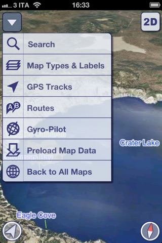
MAIN FEATURES
- Online and Offline modes
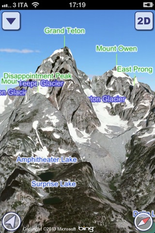
- Highly detailed 3D terrain
- GPS tracking
- Name searching (also in Offline mode)
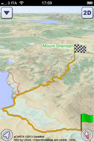
- Routing
- Altimetry graph and statistics
- Custom made gCARTA Topographic chart
- Gyroscope features: GyroPilot and First Person View
GeoFlyer 3D Maps shows you incredible quality terrain details, 3D topographic maps and aerial images, with points of interest, natural attractions, trails and paths, like nothing before.
- Before you go: plan your trip, check the tough rock passages, discover the best way-points. Take a preview of your hike, or just fly over your favorite peaks with a virtual tour.
- During your trip: record your tracks, check your ascent rates and times, improve your hiking experience in “First Person View” mode, where GeoFlyer uses your position and view direction to display what is in front of you, by using the compass and the gyroscope of your device (immersive reality).
- When you come back home: review your paths, share your saved tracks with your friends, save them for future use and check your stats information.
Maps can be stored offline on your device, so you will always follow the best path, no matter if in the middle of the forest or at the top of a mountain.
With its easy-to-use routing capabilities, GeoFlyer easily leads you to your next target!
And it’s fun: try the new GyroPilot mode and find a new entertaining way to discover and visit US National Parks. Dive into the Grand Canyon channel or into the Bryce Canyon with a low level flyby, handling your device as a virtual plane, explore the maps like a top-gun pilot!
GeoFlyers datasets also make use of the OpenStreetMap database (ODbL), a wiki worldwide map, created by enthusiastic people like you.
The App purchase includes the Yosemite Map, while all other maps can be used in Free Trial Mode for a limited period of time.
GeoFlyer… your hiking companion!
WARNING
Continued use of GPS running in the background can dramatically decrease battery life.
AVAILABLE MAPS
The Yosemite Map is included in the initial purchase. All other Maps can be purchased separately or as a bundle. Among the available maps, you will find (in alphabetical order):
- Acadia
- Arches
- Crater Lake
- Cuyahoga Valley
- Death Valley
- Glacier
- Grand Canyon
- Grand Teton
- Great Smoky Mountains
- Hot Springs
- Joshua Tree
- Mount Rainier
- North Cascades
- Olympic
- Rocky Mountain
- Sequoia and Kings Canyon
- Yellowstone
- Yosemite
- Zion and Bryce Canyon
Latest reviews of US National Parks 3D Maps app for iPhone and iPad
Hiking or biking trails are clearly demarcated together with recognizable landmarks. Tactile and responsive. Navigation appears to be flawless. Did not use map maker. Could be improved by supplying more information eg. Elevation, difficulty, and amenities. A built in link to google would be helpful.
Cool app!! very detailed maps...
Well done!
Nice app! The 3d view is much better than any other 3D mapping app; the Yosemite valley is just wonderful. Not used yet on the trails, but the hiking chart seems good.
Topo charts are very detailed. The offline mode is useful and it is working fine. My grandsons like the gyropilot, its funny.